Thursday 8 March 2012

DIED AND GONE TO AURORA HEAVEN --- STUNNING NORTHERN LIGHTS MARCH 8TH 2012

"No words can describe the experience of the Northern Lights show tonight," says photographer Jónína Óskarsdóttir. "This is just a 1s exposure!"


Is this the most breath taking Aurora you have ever seen?? :) 


AURORA NORTHERN LIGHTS IN PICTURES FROM AROUND THE GLOBE MARCH 8TH 2012

Here's some pictures of the stunning Aurora's captured on camera over the globe March 8th 2012

Enjoy :)


Solar Storm Hits Earth Right On The Nose - 8th March 2012


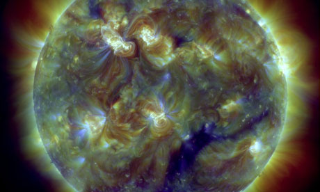
Earth's magnetic field is about to be shaken like a snow globe by the largest solar storm in five years.
After hurtling through space for a day and a half, a massive cloud of charged particles is due to arrive early Thursday and could disrupt utility grids, airline flights, satellite networks and GPS services, especially in northern areas. But the same blast could also paint colorful auroras farther from the poles than normal.
Scientists say the storm, which started with a massive solar flare earlier in the week, is growing as it races outward from the sun, expanding like a giant soap bubble. When it strikes early Thursday, the particles will be moving at 4 million mph.
"It's hitting us right in the nose," 
Astronomers say the sun has been relatively quiet for some time. And this storm, while strong, may seem fiercer because Earth has been lulled by several years of weak solar activity.
The storm is part of the sun's normal 11-year cycle, which is supposed to reach peak storminess next year. Solar storms don't harm people, but they do disrupt technology. And during the last peak around 2002, experts learned that GPS was vulnerable to solar outbursts..
The sun erupted Tuesday evening, and the most noticeable effects should arrive here Thursday, according to forecasters at the space weather center. The effects could linger through Friday morning.
In 1989, a strong solar storm knocked out the power grid in Quebec, causing 6 million people to lose power.
Solar storms can also make global positioning systems less accurate and cause GPS outages.
The storm could trigger communication problems and additional radiation around the north and south poles — a risk that will probably force airlines to reroute flights
Satellites could be affected, too. NASA spokesman Rob Navias said the space agency isn't taking any extra precautions to protect astronauts on the International Space Station from added radiation.


Saturday 3 March 2012

HUGE METEOR SPOTTED IN THE SKY OVER BRITAIN 3RD MARCH 2012

APPROXIMATELY 09:40 PM (U.K) 


A large Meteor was spotted streaking across the sky in Britain. 


Reports say the flames were BIG and orange not just a bright light, This thing was on fire and moving fast ''


http://www.youtube.com/watch?v=LEZKLBqpTk4

pic.twitter.com/xsBvlr7V

Saturday 11 February 2012

Big Freeze - Temperatures Plummet to -18°C In Britain


Coldest night of the winter as temperatures plummet to -18°C

England has shivered through the coldest night of the winter after temperatures plummeted to sub-zero readings - even on the Fahrenheit scale.  

Meteorologists said the temperature had fallen to -0.04F (-17.8C) in Chesham, Bucks, during the early hours of Saturday morning and was expected to plunge even lower as the icy weather continued to grip large areas of Britain.

Most of England and eastern Wales dropped to below 25F (-4C), but more northerly parts of the country including Scotland and Northern Ireland escaped serious cold thanks to a warm front. 


Saturday night is also forecast to be bitterly cold in England with temperatures in London and the Midlands falling to around 21F (-6C) while milder temperatures are likely on Sunday.


The Met Office said it had probably been the coldest night in England since December 2010 with temperatures below 14F (-10C) across Lincolnshire, Cambridgeshire, Oxfordshire, Hertfordshire and Bedfordshire. 


Friday 10 February 2012

Severe Weather warning! More Snow on the Way!!


Severe weather warnings for ice and snow are in place across much of England, after the second significant snowfall in less than a week.
Snow fell in most parts of England and parts of Wales overnight while other areas of the UK mainly had rain.
Ice in parts of Wales and England is causing hazardous driving conditions.
However, a "level three" cold weather alert, issued by the Department for Health, remains in place for nine parts of England, telling people to "be prepared" for severe cold weather, icy conditions and heavy snow until Monday.
''The Met office have issued a yellow warning telling people to be aware '' for snow and ice, are also in place for much of England and southern and eastern wales until midday.

Thursday 9 February 2012

''Oh No '' More SNOW On the Way... !!!!


The February freeze is continuing, with weather forecasters predicting more snow for many 
parts of England and drivers being told to avoid some roads in cumbrian roads after a series of accidents.

There were more than 97 accidents in the county on Thursday morning as rain fell on freezing roads and immediately turned to sheet ice, making conditions treacherous.


The Met Office had earlier issued a severe weather warning of ice for the north. An amber warning has been issued for the north of England warning of widespread ice, with a yellow warning for snow and ice in many parts of England, Wales and Scotland.


The worst affected areas are likely to be east Yorkshire, Lincolnshire and the east Midlands. There may be snow flurries in London this evening.


The Met Office said an area of rain had moved south from Scotland and into Wales and northern areas of England. "In places this rain is falling on to very cold surfaces, such as roads, and will freeze instantly, forming a layer of ice. Driving conditions could become hazardous, particularly where roads are untreated," it said.


An area of snow was expected to develop over east and north-east England later on Thursday, it said. During Friday this would extend into the south-west and central parts of England.
"Accumulations of up to 10cm are possible in the worst-affected regions


Beware the RAIN! 'Perfect storm' of showers falling on freezing ground causes scores of crashes causing havoc across the North East !!!!!

Freezing RAIN Causes Havoc Across The North East of England !!! 


 'Perfect storm' of showers falling on freezing ground causes scores of crashes as UK set for another four inches of snow


  • 60 road accidents across Cumbria as thick ice causes havoc

  • Six vehicles collide in freezing conditions during rush hour in Gateshead

  • Lashings of freezing rain could bring down power lines


  • Area of concern: The Met Office is predicting up to 10cm or four inches of snow on Thursday night, left, while in London the freezing weather resulted in these icicles, right


  • Wednesday 8 February 2012

    Freezing rain - could cause travel chaos to britain tomorrow !!!


    Forecasters warned up to four inches of snow will hit most of the south as two weather systems collide, with temperatures struggling to remain above freezing.
    The Met Office issued a rare “freezing rain” warning for most of northern England and southern Scotland, prompting fears of more havoc on the country’s fragile transport networks.
    Experts warned that a “very dangerous” layer of ice will create a “hazard” on pavements and roads as millions of families look to travel at the start of half term.
    Airports and electricity firms also were placed on high alert over the conditions which are said to be the biggest natural threat to airlines as ice ridges form on aircraft wings and leaving them crippled within minutes.
    The rare phenomenon occurs when rain is cooled to below 0C (32F) while falling but remains liquid before it freezes on impact with cold objects such as planes, roads, pavements and power lines.

    Full Snow moon - Amazing pics from london !!!

    Full snow moon in full glow in London - United Kingdom

    As their plane soared across a spectacular orange globe, anyone on board must have felt, well, over the moon. 
    However, while a full moon is often associated with madness, there is a more rational explanation for this dramatic image than the inauguration of lunar flights.
    The passenger jet passed across the face of the sphere in the midnight blue sky just as it was bathed in the glow of the setting sun, creating this striking scene last night. 
    The photograph was taken close to Albert Bridge in West London. The Grade II listed monument was built in 1873 and will mark the starting point of the Queen’s Diamond Jubilee flotilla on June 3.

    The striking blood-red moon pictured over London as aircraft passes in front


    City lights: A passer-by walks over Battersea bridge as the scarlet globe glows in the sky

    Freezing rain forecast tomorrow for Scotland - Northern England says the Met office !!!!

    Freezing rain could be possible tonight across Scotland and The north of England the Met office warned today..
    Conditions have to be ‘just right’ to get freezing rain and it doesn’t happen very often in the UK, making it a relatively rare phenomenon.
    The effects of freezing rain can have large impacts. It can create a layer of ice on anything cold it comes into contact with – this means not only a potential for icy roads and pavements, but also a risk to things like aircraft and powerlines.
    Freezing rain is the name given to rain that falls when surface temperatures are below freezing. The raindrops become super cooled while passing through a sub-freezing layer of air, many hundred feet (or meters), just above the surface, and then freeze upon impact with any object they encounter. The resulting ice, called glaze, can accumulate to a thickness of several centimeters
    A storm that produces a significant thickness of glaze ice from freezing rain is often referred to as an “ice storm“.
    Freezing Rain